

WATCH NOW
Watch on the app














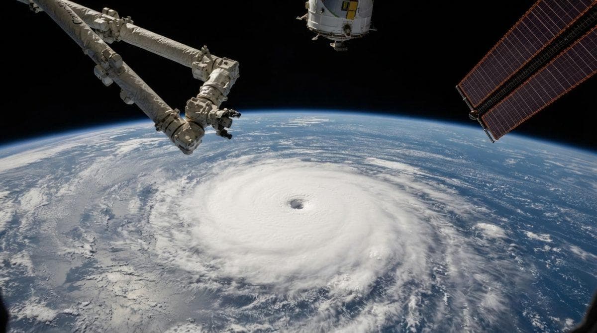
El Niño gave Hurricane Polo never-before-seen power and fueled its explosive growth
-
El Niño intensified Hurricane Polo, unleashing an unprecedented meteorological phenomenon driven by explosive thermal growth across the entire Pacific basin during the season.
-
Atmospheric specialists evaluate warm sea surface temperatures alongside reduced wind shear as the primary catalysts for the rapid storm intensification recorded in recent satellite telemetry.
-
Coastal communities monitor updated meteorological forecasting models while federal agencies issue comprehensive advisories regarding extreme tropical storm activity across the region.
El Niño intensified Hurricane Polo through exceptionally warm Pacific waters, providing unprecedented thermal energy that dramatically accelerated the storm system while federal meteorologists recorded sustained wind speeds surpassing previous seasonal thresholds, while tropical researchers at NOAA documented how anomalous oceanic heat fluxes combined with favorable atmospheric humidity to drive the meteorological anomaly, whereas regional emergency management teams activated enhanced preparedness protocols across vulnerable coastal sectors.
Ver esta publicación en Instagram
Atmospheric dynamics driving extreme meteorological anomalies
Upper air instability reached critical thresholds as surface temperatures across the tropical Pacific exceeded seasonal averages by significant margins, creating an optimal thermodynamic environment for rapid cyclonic organization, pressure gradients in the upper levels aligned perfectly with moisture-laden air masses to facilitate continuous updraft development within the core of the circulation; meanwhile specialist meteorologists emphasize that regional wind shear values dropped to near-zero levels during the peak development window, explosive storm growth.
Effectively removing the primary atmospheric barrier that typically disrupts tropical cyclones before they achieve maximum intensity, consequently, computer simulation models processed how El Niño amplified the sheer velocity of the strengthening process.
Ver esta publicación en Instagram
Satellite analysis and hurricane thermodynamics
Orbital instruments captured unprecedented cloudtop cooling rates within the eyewall region, signaling a profound release of latent heat that powered the system into a major category status within a remarkably compressed timeframe, meanwhile surface buoy networks recorded dropping barometric pressures that confirmed the immense rotational force generated by the thermal feedback loop, in addition, independent climatologists point out that similar thermodynamic triggers have historically accompanied catastrophic marine heatwaves, highlighting a growing correlation between broader oceanic warming trends and the frequency of sudden intensification events, moreover, government research vessels continue deploying specialized sensors to measure subsurface heat content and salinity layers that sustained the phenomenon.
Comprehensive breakdown of regional weather impacts
Coastal wave heights exceeded 20 ft along remote shorelines as powerful swells radiated outward from the core of the cyclone, marine navigation advisories restricted commercial vessel traffic across primary shipping lanes within the eastern Pacific operational sector, precipitation totals surpassed 6 in within 48 hours across elevated terrain zones adjacent to the primary trajectory path, explosive storm growth.
Emergency response agencies deployed swift water rescue units to designated staging areas ahead of predicted flash flood events, and satellite communications grids maintained uninterrupted data streams for meteorological institutions tracking structural changes where El Niño surged the eyewall.
Stations dedicated to ecological observation registered severe barometric pressure drops across offshore islands as the powerful vortex tracked northwestward, prompting immediate coordination between international meteorological networks, subsequently, oceanographic teams analyzed salinity profiles to determine how stratified water layers influenced the transfer of thermal energy into the lower troposphere, concurrently aviation reconnaissance crews completed multiple challenging flights directly into the eye of the system, gathering critical dropsonde data that validated theoretical models concerning how El Niño boosted surface wind velocities, similarly, state disaster authorities utilized these real time telemetry inputs to refine evacuation timelines for vulnerable coastal settlements.
Critical challenges in current meteorological prediction systems
Sudden surges of thermal energy in the ocean pose extraordinary operational challenges for global forecasting centers, because they disrupt the stability of traditional variables and drastically reduce the window of institutional maneuvering time, likewise, these unforeseen acceleration dynamics complicate civil protection duties by limiting the time available to issue precise early warnings to communities located in the direct path of hurricanes that escalate abruptly from a minor category to a severe one within 24 hours, beyond that climate analysts stress that current oceanic variability demands constant updates to supercomputing platforms and real-time observation protocols, thereby ensuring that emergency teams anticipate extreme changes driven by global oceanic phenomena, furthermore, scientific institutions promote the integration of artificial intelligence to process complex thermal anomalies before they transform into imminent threats for coastal regions.
Algorithm innovation and international cooperation
Government research centers continuously evaluate the accuracy of their predictive algorithms when faced with these extreme events, recognizing that historical patterns no longer suffice to anticipate the speed at which cyclones absorb energy in warm environments, experts seek to minimize information gaps during the early stages of cyclonic formation to prevent operational surprises on dry land, explosive storm growth; furthermore, this necessity for technological adaptation drives international cooperation among meteorological agencies, allowing them to share advanced orbital data and ocean buoy measurements with greater agility, consequently, the evolution of forecasting methods remains vital for protecting urban infrastructure and reducing the vulnerability of coastal populations against unexpected meteorological threats.
Long term climatological implications and institutional research where El Niño elevated global patterns
-
Scientific units evaluate how overlapping cyclic oscillations alter the predictability of modern tropical meteorology across 10-year observational blocks, whereas predictive models require substantial adjustments to measure the compounded impact of persistent marine heat anomalies affecting 100% of regional grids.
-
Governments finance deep-water sensor arrays and advanced observation radars spanning over 50 specific coastal sectors, additionally, academic institutions collaborate closely with space agencies to optimize the collection of real-time orbital data where El Niño supercharged atmospheric tracking.
-
Policy advisors reassess zoning frameworks and insurance policies in the face of escalating disaster costs exceeding $1,000,000 per municipality, furthermore experts continuously investigate the mechanisms through which this historic tropical system evolved across 3 distinct oceanic phases where El Niño intensified Hurricane Polo, driving proactive adaptation frameworks designed to safeguard vulnerable coastal populations against future climatic volatility.
For additional meteorological insights, you can review official advisories via the NOAA National Hurricane Center portal or track global updates through the World Meteorological Organization platform.
